A friend predicted awhile back that the massive animal die offs would start to contain larger & larger animals. At first they were Krill & Minnow & small birds. Then in Galveston TX they were Chad (Google them) which are definitely bigger fish. Now Squid. This is all a sign that sulphuric acid is filling the oceans & the air from volcanoes both underwater & above surface.
http://screen.yahoo.com/squidocalypse-upon-us-005014857.html
Thursday, December 13, 2012
Thursday, November 15, 2012
Planet X Found ??
As some of you know I am a medium with many medium friends & one of my friends mentioned that there is a rogue planet out there larger than Jupiter .. & then this story comes out. Is this Planet X or Nibiru ? Another friend in this circle is said to have a picture of this planet .. tho I have not seen it yet. Also, the last 5 or so major earthquakes have all been 188 days apart exactly which implies there is a planet/dwarf star out there which passes thru our solar system in a 376 day orbit roughly ?? so each time it aligns with our sun (much like Elenin) it causes a gravitational pull which causes earthquakes ... is the establishment admitting its existence now bcuz it knows it can no longer hide it ??
'Orphan' Alien Planet Found Nearby Without Parent Star
The free-floating object, called CFBDSIR2149, is likely a gas giant planet four to seven times more massive than Jupiter, scientists say in a new study unveiled today (Nov. 14). The planet cruises unbound through space relatively close to Earth (in astronomical terms), perhaps after being booted from its own solar system.
"If this little object is a planet that has been ejected from its native system, it conjures up the striking image of orphaned worlds, drifting in the emptiness of space," study leader Philippe Delorme, of the Institute of Planetology and Astrophysics of Grenoble in France, said in a statement.
Orphan planet, or something else?
Delorme and his team discovered CFBDSIR2149 using the Canada-France-Hawaii Telescope, then examined its properties with the European Southern Observatory's Very Large Telescope in Chile. [Video: Rogue Planet Has No Parent Star]
The newfound object appears to be among a stream of young stars called the AB Doradus moving group, the closest such stream to our own solar system.
Scientists think the AB Doradus stars all formed together between 50 million and 120 million years ago. If CFBDSIR2149 is indeed associated with the group — and researchers cite a nearly 90 percent probability — then the object is similarly young.
And if the discovery team is right about CFBDSIR2149's age, the body is likely a planet, with an average temperature of 806 degrees Fahrenheit (430 degrees Celsius), researchers said.
There's still a slight chance that CFBDSIR2149 is a brown dwarf — a strange object that's larger than a planet but too small to trigger the internal nuclear fusion reactions required to become a full-fledged star. Additional observations should help decide the matter.
"We need new observations to confirm that this object belongs to the AB Doradus moving group," Delorme told SPACE.com via email. "With a good distance measurement and a more accurate proper motion, we will be able to increase (or decrease) the probability that it is indeed a planet."
The new study was published today in the journal Astronomy & Astrophysics.
Billions of starless planets?
The discovery of a starless alien planet would not be shocking, at least not anymore. In the last year or so, astronomers have spotted a number of such orphan worlds — so many, in fact, that some scientists think parentless planets are the rule rather than the exception.
One 2011 study, for example, estimated that rogue worlds outnumber "normal" planets with obvious host stars by at least 50 percent throughout the Milky Way. If that's the case, the galaxy that includes Earth probably also hosts billions of orphan planets.
And gas giants may be in the minority among these solitary wanderers, researchers say.
"We now know that such massive planets are rare and that Neptunes or Earth-mass planets are much more common," Delorme said. "We also know that massive objects are more difficult to eject [from solar systems] than light ones. If you follow the rationale, you deduce that ejected exo-Neptunes and ejected exo-Earths should be much more common than objects like CFBDSIR2149."
It's exciting to have a starless planet so close to Earth, researchers say. Future telescopes should be able to learn a great deal about CFBDSIR2149, since they won't have to contend with the overwhelming glare of a nearby host star.
"This object is a really easy-to-study prototype of the 'normal' giant planets we hope to discover and study with the upcoming generation of direct-imaging instruments," Delorme said. "It will help to improve our forecast of these objects' luminosity and hence help us discover them ?and, once discovered, it will help us understand the physics of their atmospheres."

Saturday, October 13, 2012
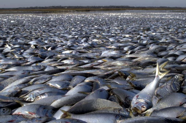
Larger Fish Washing Ashore ?
My Friend AJ, who is the most advanced man or medium on the planet, has said that we will know earth changes are closer when the size of the fish that wash ashore grow larger as that will mean there is more sulphuric acid being released from underwater volcanoes ... this also applies to birds falling out of the sky due to above ground volcanoes ... at first the fish were minnows & Krill which if u google those u can see they are very small ... in Galveston, TX this year Shad washed ashore ... a massive die off ... but these fish are much larger ... look them up ... now this fish is huge !! Only one ... but watch out for more ... & for any fish or bird die offs ... especially in Italy as that is where the first Super Volcano can go off ... then Indonesia then YellowStone USA .... Good Luck !!
Sea Monster washes ashore ?
Sea Monster washes ashore ?
Wednesday, October 3, 2012
Wednesday, September 5, 2012
Monday, August 27, 2012
Safe Locations After Earth Changes
Jesus tells us where the safest places will be after earth changes ....
http://www.youtube.com/watch?v=Z5ajddZoM5U&feature=plcp
http://www.youtube.com/watch?v=Z5ajddZoM5U&feature=plcp
Series of earthquakes rattle Southern California
My phone was blowing up all day with quake report notifications from twitter ... I've never seen anything like it ... which is also the #1 quote I've heard from scientists these last years ... "I've never seen anything like it" ....... this is the 14,000 year cycle happening all over again ... massive earth changes are upon us ... also an 8.0 earthquake or greater should happen every 150 years in California ... it has been over 300 years ... tic toc ...
SAN DIEGO (AP) — Dozens of small to moderate earthquakes struck southeastern California on Sunday, knocking trailer homes off their foundations, shattering windows and rattling nerves in a small farming town east of San Diego.
The largest quake, at 1:57 p.m., registered at a magnitude 5.5 and was centered about three miles northwest of the town of Brawley, said Robert Graves, a geophysicist with the U.S. Geological Survey. Another quake about an hour and a half earlier registered at magnitude 5.3.
No injuries were reported.
More than 30 additional earthquakes with magnitudes of at least 3.5 jiggled the same area near the southern end of the Salton Sea, Graves said.
"The type of activity that we're seeing could possibly continue for several hours or even days," Graves said.
The quakes pushed 20 mobile homes at a trailer park off their foundations, displacing the families that lived in them, said Maria Peinado, a spokeswoman for the Imperial County Emergency Operations Center.
Sporadic power outages affecting 2,500 Imperial Irrigation District customers also prompted authorities to evacuate some patients from one of the county's two hospitals.
By late Sunday, a magnitude-5.1 quaked followed by several more with magnitudes of at least 4.0 shook the area.
"We're all on edge here," said George Nava, the mayor of Brawley, a town of 25,000. "It's not uncommon for us to have earthquakes out here, but at this frequency and at this magnitude it's fairly unusual."
At the El Sol Market in Brawley, food packages fell from shelves and littered the aisles.
Several glasses and a bottle of wine crashed to the floor and shattered at Assaggio, an Italian restaurant in Brawley, said owner Jerry Ma. The shaking was short-lived but intense, he said.
"It felt like there was quake every 15 minutes. One after another. My kids are small and they're scared and don't want to come back inside," said Mike Patel, who manages Townhouse Inn & Suites in Brawley.
A TV came crashing down and a few light fixtures broke inside the motel, Patel said.
A Brawley police dispatcher said several downtown buildings sustained minor damage.
The first quake, with a magnitude of 3.9, occurred at 10:02 a.m. The USGS said more than 100 aftershocks struck the same approximate epicenter, about 16 miles north of El Centro.
Some shaking was felt along the San Diego County coast in Del Mar, some 120 miles from the epicenter, as well as in the Coachella Valley, southern Orange County and parts of northern Mexico.
USGS seismologist Lucy Jones said earthquake swarms are characteristic of the region, known as the Brawley Seismic Zone.
"The area sees lots of events at once, with many close to the largest magnitude, rather than one main shock with several much smaller aftershocks," Jones said.
The last major swarm was in 2005, following a magnitude-5.1 quake, she said.
Sunday's quake cluster occurred in what scientists call a transition zone between the Imperial and San Andreas faults, so they weren't assigning the earthquakes to either fault, Graves said.
Friday, August 17, 2012
Wednesday, August 15, 2012
Tuesday, August 14, 2012
Hundreds of thousands of dead fish wash ashore near Galveston, Tx in massive fish kill
Is this being caused by underwater volcanoes giving off toxic gas ?? So many fish & bird die offs in so little time ?
http://theextinctionprotocol.wordpress.com/2012/08/14/hundreds-of-thousands-of-dead1-fish-ashore-near-galveston-tx-in-massive-fish-kill/
August 14, 2012 – GALVESTON, TX – Hundreds of thousands of dead fish have washed up on the beach in Galveston, where crews went to work Monday to remove the dead fish. Peter Davis of the Galveston Island Beach Patrol said Sunday the small shad fish likely were killed by low oxygen levels in the Gulf of Mexico. Davis estimated hundreds of thousands of fish have died. Galveston County health officials said the water is fine for beachgoers. Biologist Steven Mitchell with the Texas Parks and Wildlife Department said calm conditions and summer heat may have contributed to the fish kill. He said there’s a possibility of a dead zone in the water off Galveston. Though testing is expected this week, some officials are already blaming the fish kill on red tide. –KWTX
http://theextinctionprotocol.wordpress.com/2012/08/14/hundreds-of-thousands-of-dead1-fish-ashore-near-galveston-tx-in-massive-fish-kill/
Monday, August 13, 2012
Underwater Volcanoes Erupting
More unusual activity leading up to massive earth changes ... There are volcanoes now active in the world that haven't been active for hundreds or thousands of years ... coincidence ?
Our volcanoes are more unpredictable than we ever realised, new research reveals. Ruapehu, White Island, Tongariro, Auckland . . . the whole North Island is a tin lid clipped atop a pressure cooker, as shown by this week's eruptions. So why are we still so complacent - and why is the property around Auckland's volcanic cones still the most valuable in the country?
Kerry Wakelin friend woke her from her sleep. That was unusual. Rupert, a Jack Russell-cross, doesn't generally ask to be taken for midnight walks along the track near the web designer's apartment, tucked at the foot of Mt Tongariro.
"The next thing, the sky lit up like a big flash of lightning followed by a huge grumbling noise," Wakelin says. "Then I saw a large black cloud appear near the mountain. I assumed it was a bad storm, so went in and went straight back to bed."
What she had unwitting witnessed was the volcano erupting for the first time in 115 years. It rumbled into life at 11.50pm on Monday, throwing ash and rock a kilometre into the air, sparking a potential threat warning for Central North Island regions.
"I didn't know until the morning it was an eruption I had seen," she explains.
"And then I realised Rupert had woken me up and wanted out because he must have felt the tremors."
Wakelin, 47, had worked at the Whakapapa ski field during the major eruptions on Mt Ruapehu in the mid-1990s and insists she isn't fazed by the simmering volcano on
her doorstep. "The Ruapehu situation was scary but the Tongariro eruption was more like a fart. It was nothing, really."
her doorstep. "The Ruapehu situation was scary but the Tongariro eruption was more like a fart. It was nothing, really."
Nothing, really. Nothing, when hectares of farmland are coated in ash. Nothing, when boulders smash through the roof, water tank and beds in Ketetahi Springs Hut. Nothing,
when flights in and out of the east side of the North Island are shut down. Maybe it's because we're such a famously stoic people, but would the people of any other nation describe such an eruption as "nothing, really"?
when flights in and out of the east side of the North Island are shut down. Maybe it's because we're such a famously stoic people, but would the people of any other nation describe such an eruption as "nothing, really"?
"Stoic" is the generous description. A more accurate one might be "complacent".
New research by Devora (Determining Volcanic Risk in Auckland), a multi-agency project to determine Auckland's volcanic risk, has discovered previously unknown levels of volatility in this country's volcanoes. This heightened risk, disclosed by Devora project team leaders to the Herald on Sunday, should be a wake-up call to Aucklanders, in particular.
Next month, a Civil Defence exercise will try to shock New Zealand into action by enlisting a million of us-at home, work and school-to participate in the world's first nationwide earthquake drill.
Civil Defence national information boss Vince Cholewa observes: "It's the kids we really have to get through to from an early age, so awareness and preparation for a major national disaster comes almost second nature and is passed to future generations."
New Zealand's varied landscape and its towering mountain peaks owe a lot to the tectonic uplift of land and volcanic eruptions caused by the Pacific and Indo-Australian Plates clashing beneath the Earth's surface, which has left parts of the country seismically active.
The world's most dramatic volcanic eruption in 5000 years occurred here about 200AD. The Taupo eruption devastated much of the central North Island, emptying Lake Taupo in the process.
Since Maori first settled here, they have seen volcanoes Tarawera, Rangitoto, Taranaki, Tongariro, Ngauruhoe, Ruapehu and White Island intermittently and unpredictably spew out fountains of hot ash or lava.
The once-dazzling pink and white terraces on the shores of Lake Rotomahana were New Zealand's greatest national treasure.
They were cherished by Maori and known far and wide as the eighth natural wonder of the world. Then, during an immense volcanic eruption in 1886, they disappeared. They now lie below the lake.
Mt Ruapehu erupted most recently in 1995 and 1996. Mud flowed through the Whakapapa ski field and the slopes of the mountain were coated with volcanic ash.
Auckland, a city of 1.4 million people, sits uneasily atop more than 50 volcanic cones.
We have always been told about the danger of earthquakes - but the volcanoes, they told us, were dormant. Well, this week one of them erupted ...
New, unpublished scientific research disclosed to the Herald on Sunday shows there has been a lot more volcanic activity in the past than first thought, meaning the country's volcanoes, especially around Auckland, could be more unpredictable than previously believed.
A volcanic eruption in Auckland in the next 50 years has about a 4 per cent likelihood, although "considerable uncertainty surrounds this figure", according to the Ministry of Civil Defence and Emergency Management.
Last year, four new volcanic craters were discovered underneath South Auckland by Geomarine Research, bringing the total number of volcanoes in the Auckland volcanic field to 55. The most prominent of the new finds is a 300m diameter crater surrounded by a semicircular rim of volcanic ash in Boggust Park in Favona, Mangere. The other three craters are in Puhinui Reserve, Wiri.
Geomarine Research's Hugh Grenfell believes complacent Aucklanders should treat the sudden eruption at Tongariro as a wake-up call.
"There are a number of other places in the world with volcanic fields, the difference is none has a city the size of Auckland built on them," the geologist says.
A main focus for scientists and researchers from the seven-year Devora project has been boring into sediment layers deep under volcanic crater lakes such as Lake Pupuke at Takapuna to determine more accurate levels of activity over time.
The results have been surprising. Previously undiscovered layers of ash found under the lakes from other volcanoes further south, including Taupo, Okataina and Tongariro, suggest that New Zealand has undergone more volcanic activity than first believed.
Dr Jan Lindsay, one of the country's leading volcanologists, is a leader of Devora.
She says tests on new layers of sediment show Auckland has undergone a lot more volcanic movement in the past 30,000 years than known before. This raises questions about the future volatility of all Auckland's volcanoes.
Worse case scenarios for the city include Rangitoto Island blowing apart, vapourising
everything in its path, or cones the size of Mt Eden bursting out in Queen St, uprooting buildings and destroying infrastructure.
everything in its path, or cones the size of Mt Eden bursting out in Queen St, uprooting buildings and destroying infrastructure.
If magma was to travel 80km to the surface and hit sea water, the eruption would create a catastrophic explosion, says Lindsay. "There would be clouds of hot ash and steam. It would be a very significant event," she explains.
An eruption in the city centre could be just as devastating. "If the magma kept coming and there was enough of it, it could produce a scoria cone as big as Mt Wellington in the heart of the CBD."
Lindsay also reveals new findings showing Rangitoto is likely to have erupted more often than first thought.
"We used to think that a volcano wouldn't erupt twice but now we know that might not be the case. Imagine if a volcano the size of Rangitoto popped up in downtown Auckland? That could happen, because it has happened in the past.
"And who knows when the next one would be-it could be next week or in a thousand years. That is just the way it is."
Lindsay does stress that despite the large number of volcanoes in Auckland, she believes the field is currently stable and a greater threat to the city is likely to come from the fallout from a large eruption in the central North Island or elsewhere.
That is why volcanologists from around the world, including Dr Tom Wilson from GNS Science, descended on Tongariro this week.
"In Chile, I saw the damage volcanic ash can do from the eruption there last year. If the same thing was to happen in New Zealand it would be catastrophic," he says.
"Cities and towns would grind to a halt, waterways would be clogged up and the land that livestock feeds on would be so badly affected thousands of animals would die from starvation or poisoning."
If an eruption the size of this week's one occurred in Auckland, the chaos would be immense, says the city's Civil Defence boss Clive Manley.
"Depending on the time of day, up to half a million people would be evacuated to outside of a 5km exclusion zone," he explains.
"I would expect a 3km zone to be severely impacted by an event such as one in Tongariro. Ash would close the airport, roads would be shut, power and water supplies cut off and thousands of business affected."
It is estimated Auckland's GDP would drop by 47 per cent in the short term at least, costing the country billions of dollars.
"How long it would take to recover economically from something like that is anyone's guess," Manley says. He won't speculate at numbers of potential casualties but believes most deaths or injuries would likely be caused by people refusing to leave the area or their homes.
"History shows that this has been the case in a lot of major evacuations around the world.
"Hurricane Katrina in the United States a few years back was one of the best-managed evacuations ever, but there was still a lot of casualties from people who just wouldn't budge. And you can't force them."
Auckland University PhD student Bob Wang has his bags packed . His car at home in Epsom is loaded with emergency equipment, including food, water, torches, batteries and a tent. He is ready to meet members of his family at a prearranged spot for them to escape the city as quickly as possible following an unexpected volcanic eruption. He has prepared a DIY emergency plan to follow in case of a major event.
"I have taken a first-aid course and learned some survival techniques. I also have developed a habit of keeping my car topped up with petrol."
The 26-year-old is studying electrical engineering at the University of Auckland. He says people are all talk but no action and he is worried by their complacency.
He is so concerned about volcanoes going off he tried to form a survivalist group. He was disappointed there were no takers.
On internet blogs and forums, pockets of concerned citizens such as Wang swap survival tips and information about Auckland's volcanoes. But they are in the minority.
Wang's concern may seem excessive, but Civil Defence chief Manley reveals most of us err on the side of unpreparedness. Most Aucklanders feel too safe and therefore think it's not worth the bother of preparing for an eruption, he says.
Frustratingly, little has been learned fromthe deadly earthquake in Christchurch.
"Our latest research shows Aucklanders are the least prepared in the country. It is great they feel they live in a safe place but because of the number of volcanoes it is not wise to simply ignore planning what you would do if a natural catastrophic occurred.
"They seem to think they are in a place with plenty of resources and nothing will happen to them."
Manley adds: "There was a big spike in awareness after the big Christchurch earthquake but that has pegged back dramatically. People in Christchurch and Wellington are twice as well prepared as Aucklanders."
Auckland does not look like a city built on a volcano. The views and lush plant growth afforded by the volcanic cones make them some of the city's most lucrative real estate.
Real estate firms say people are even battling to buy in volcanic hot spots. Interest in areas such as Mt Eden, Epsom and Hobson has never been higher and people are still prepared to pay top dollar to be in the zones for the best grammar schools.
House values in Auckland are still soaring. Prices rose 3.1 per cent in the three months just gone, with an average sale price of $656,846. Values are up 6.3 per cent on an annual basis.
"People in Mt Eden and Mt Wellington are more concerned about the school fees erupting than they are about a volcano going off in the garden," says Michael Williams, regional manager for Barfoot &Thompson. "It is just not an issue and never has been. At recent auctions, people have been swinging from the rafters to get in and buy a house."
The truth is, New Zealand has volcanoes and quakes and storms and much more. They will always be with us. If you want to be entirely safe you are in the wrong country.
If we are going to build our houses atop a simmering pressure cooker, we can at least manage the risk.
In the event of an eruption, the Government's Get Ready, Get Thru website advises doing all the usual things like putting together an emergency kit and a household emergency plan. You should also have essential emergency items in your workplace and in your car.
And the nationwide ShakeOut drill, beginning at 9.26am on September 26, will give all New Zealanders a chance to test and ready themselves.
About 700,000 Kiwis the length and breadth of New Zealand have so far pledged their support through a campaign targeting schools and businesses - but more are welcome, says Civil Defence public information boss Cholewa.
"It is a worry when people's safety plan is based on not being prepared," Cholewa says. "It is perhaps even timely that the eruption happened in Tongariro and that no one was hurt or extensive damage done.
"It will perhaps remind people about the importance of being prepared through joining the Shake-Out event and getting up to a million people participating in practising 'Drop, Cover, Hold'.
"Some people in Auckland might think this is only relevant for earthquakes but you have to remember that any volcanic eruption in the Auckland region would be preceded by a series of quakes anyway."
The possibilities for carnage and chaos from our volatile volcanoes seem to be endless.
But back under the shadow of rumbling Mt Tongariro, dog-lover Wakelin isn't concerned about the danger brewing in her backyard.
"When I was caught up the Ruapehu eruption I was frightened and worried that something catastrophic was going to happen, and it didn't," she says. "Having been living close to the mountains for years I have learned to live with the situation and I'm pretty comfortable with it.
"I'll be back out on the tracks walking Rupert tonight, same as usual."
Friday, August 10, 2012
Bizarre rock 'ice shelf' found in Pacific
A huge cluster of floating volcanic rocks covering almost 26,000 square kilometres (10,000 square miles) has been found drifting in the Pacific, the New Zealand navy said Friday.
The strange phenomenon, which witnesses said resembled a polar ice shelf, was made up of lightweight pumice expelled from an underwater volcano, the navy said.
An air force plane spotted the rocks on Thursday about 1,000 kilometres (600 miles) offshore from New Zealand and warned a navy warship that it was heading towards them.
[Slideshow: Giant iceberg's birth seen from space]
Lieutenant Tim Oscar said that while he knew his ship the HMNZS Canterbury was in no danger from the pumice, which is solidified lava filled with air bubbles, it was still "the weirdest thing I've seen in 18 years at sea".
"As far ahead as I could observe was a raft of pumice moving up and down with the swell," he said.
"The rock looked to be sitting two foot (half a metre) above the surface of the waves and lit up a brilliant while colour in the spotlight. It looked exactly like the edge of an ice shelf."
[Slideshow: Amazing volcano lightning photos]
Scientists aboard the ship said the pumice probably came from an underwater volcano called Monowai, which has been active recently.
They said the phenomenon was unrelated to increased volcanic activity in New Zealand this week, including an eruption at Mount Tongariro that sent an ash cloud 20,000 feet into the atmosphere.
Thursday, August 9, 2012
Tuesday, August 7, 2012
‘Super Volcano’ could kill millions near site of Pompeii
")
This is one of the super volcanoes that can go off within months ... along with the Yellowstone Super volcanoes in the USA & The Indonesia Super Volcano ... interesting that they have now suddenly "found" it
The eruption of Mount Vesuvius near Naples, Italy, in 79 A.D. killed thousands of Pompeii residents and remains one of the most famous volcanic explosions in history. But scientists say a hidden "super volcano" in the same area has the potential to kill millions.
"These areas can give rise to the only eruptions that can have global catastrophic effects comparable to major meteorite impacts," Giuseppe De Natale, head of a project to drill deep under the earth to monitor the molten caldera, told Reuters.
A caldera, or cauldron, is formed by collapsed land after a volcanic eruption. It can be just as dangerous as volcanic domes, sending magma and ash shooting into the air. A caldera is located in Campi Flegrei. The regional park, which is named after the Greek word for burning, is a major tourist attraction, and the surrounding area is home to more than 3 million residents.
"That is why the Campi Flegrei absolutely must be studied and monitored," De Natale said. "I wouldn't say like others, but much more than the others exactly because of the danger given that millions of people live in the volcano."
Scientists funded by the International Continental Scientific Drilling Programme have been given clearance to drill 2.2 miles underground into the center of the caldera, home to a giant chamber of molten rock. Once they've reached the chamber, they plan to install a monitoring system that would give advanced warning of any potentially dangerous eruptions.
"[S]ome of these areas, in particular the Campi Flegrei, are densely populated and therefore even small eruptions, which are the most probable, fortunately, can pose risks for the population," said De Natale, from the Vesuvius observatory at Italy's National Institute for Geophysics and Volcanology.
The initial stages of drilling have already turned up some scientific evidence, including samples of volcanic rock from a major eruption that occurred some 15,000 years ago.
Wednesday, August 1, 2012
Thursday, July 26, 2012
2012 - Weird Events
The following video is a collection of weird events that have happened on the planet... in just the first three months of 2012. ......
How much more proof do you need ??
http://www.sott.net/articles/show/248656-2012-Something-Is-Going-On
How much more proof do you need ??
http://www.sott.net/articles/show/248656-2012-Something-Is-Going-On
Drought Worsens, Food Inflation to Rise
CHICAGO/WASHINGTON (Reuters) - Scattered rain brought some relief to parts of the baking U.S. Midwest on Wednesday, but most of the region remained in the grips of the worst drought in half a century as the outlook for world food supplies and prices worsened.
The U.S. Agriculture Department forecast that food prices would now out-pace other consumer costs through 2013 as drought destroys crops and erodes supplies.
"The drought is really going to hit food prices next year," said USDAeconomist Richard Volpe, adding that pressure on food prices would start building later this year.
"It's already affecting corn and soybean prices, but then it has to work its way all the way through the system into feed prices and then animal prices, then wholesale prices and then finally, retail prices," Volpe said in an interview.
The USDA now sees food prices rising between 2.5 percent and 3.5 percent in 2012 and another 3-4 percent in 2013.
Food prices will rise more rapidly than overall U.S. inflation, the USDA said, a turnabout from the usual pattern. U.S. inflation is estimated at 2 percent this year and 1.9 percent in 2013. Food inflation was 3.7 percent last year but only 0.8 percent in 2010.
On Wednesday, the USDA added another 76 counties to its list of areas designated for disaster aid, bringing the total to 1,369 counties in 31 states across the country. Two-thirds of the United States is now in mild or extreme drought, the agency said.
Forecasters said that after weeks of hot, dry weather the northern Corn Belt from eastern Nebraska through northern Illinois was likely to see a second day of scattered rain. But in the southern Midwest, including Missouri and most of Illinois, Indiana and Ohio, more hot, dry weather was likely.
"Most of these areas need an excess of 10 inches of rain to break the drought," said Jim Keeney, aNational Weather Service meteorologist, referring to Kansas through Ohio. "This front is not expected to bring much more than a 1/2 to 1 inch in any particular area. It's not a drought buster by any means."
The central and southern Midwest saw more temperatures above 100 degrees Fahrenheit on Wednesday, with St Louis at 101 F.
"There's no change in the drought pattern, just thunderstorms shifting around," said Andy Karst, a meteorologist for World Weather Inc. "There are no soaking rains seen through August 8."
The outlook sent Chicago Board of Trade grain markets higher after prices had come down from last week's record highs.
Chicago Board of Trade corn for September delivery closed 4-1/2 cents higher at $7.94-1/2 a bushel, compared to the record high of $8.28-3/4 set last week. August soybeans ended 45 cents higher at $16.94-1/4, compared to last week's record of $17.77-3/4. September wheat rose 24-1/2 cents at $9.03-1/4, compared to last week's 4-year high at $9.47-1/4.
The prices have markets around the world concerned that local food costs will soar because imports will be expensive, food aid for countries from China to Egypt will not be available, and food riots could occur as in the past.
The United States is the world's largest exporter of corn, soybeans and wheat.
Major losses in the massive U.S. corn crop, which is used for dozens of products from ethanol fuels to livestock feed, have been reported by field tours this week.
Soybeans, planted later than corn, are struggling to set pods, but if rain that has been forecast falls, soybeans may be saved from the worst effects of the drought.
A Reuters poll on Tuesday showed that U.S. corn yields could fall to a 10-year low, and the harvest could end up being the lowest in six years. Extensive damage has already been reflected in declining weekly crop reports from Corn Belt states.
"Monday's crop ratings showed losses on par with the damage seen during the 1988 drought if these conditions persist," said Bryce Knorr, senior editor for Farm Futures Magazine. "Weather so far has taken almost 4 billion bushels off the corn crop, so a lot of demand must still be rationed."
In Putnam County, Indiana, this week, crop scouts did not even stop to inspect corn fields since a glance convinced them that farmers would plow crops under rather than trying to harvest anything.
On Wednesday, scouts in central Illinois reported that some corn fields were better than expected, having benefited from early planting and pollination after a warm winter and spring.
Tom Womack of the Tennessee Department of Agriculture said some recent rains had helped soybean prospects, but "the damage that has been done to the corn has been done. No amount of rainfall will help us recover what we lost in the corn crop."
Ohio Governor John Kasich signed an order on Wednesday that will allow farmers to cut hay for their livestock from grass growing along highways adjacent to their properties.
Fire threats were growing in portions of the Plains. On Wednesday, firefighters from three north-central Nebraska counties and the National Guard battled expanding wildfires that have consumed more than 60,000 acres in the last week.
On Wednesday, helicopters dumped water on wildfires, ignited by lightning, that have been burning since the weekend in the Niobrara River Valley.
"We are making progress, but continued support is needed," Nebraska Governor Dave Heineman said.
In Missouri, one of the nation's driest states, the highway patrol said smoke from grass and brush fires was creating "very dangerous driving conditions." Discarded cigarettes were cited as a factor in those fires.
Across the Midwest, cities and towns restricted water use for gardens and lawns and tried to save stressed trees with drip bags. Reservoir and river levels were low and being carefully watched, and restrictions were placed on barge movements along the Mississippi River and recreational boating.
SHAPE OF THINGS TO COME?
The U.S. drought has been blamed on the El Nino phenomenon in the western Pacific Ocean, a warming of sea temperatures that affects global atmosphere and can prevent moisture from the Gulf of Mexico from reaching the U.S. Midwest breadbasket.
Some scientists have warned that this year's U.S. drought, already deemed the worst since 1956, is tied to climate factors that could have even worse effects in coming years.
Dangerously hot summer days have become more common across the Midwest in the last 60 years, and the region will face more potentially deadly weather as the climate warms, according to a report issued by the Union of Concerned Scientists (USC) on Wednesday.
The report looked at weather trends in Chicago, Cincinnati, Detroit, Minneapolis and St. Louis and smaller cities such as Peoria, Illinois, and Toledo, Ohio.
The report found that the number of hot, humid days has increased, on average, across the Midwest since the 1940s and 1950s, while hot, dry days have become hotter.
Finding relief from the heat has become more difficult, as all the cities studied now have fewer cool, dry days in the summer and night-time temperatures have risen.
"Night-time is typically when people get relief, especially those who don't have air conditioning," said Steve Frenkel, UCS's Midwest office director. "The risks of heat-related illness and death increase with high nighttime temperatures."
In Chicago, more than 700 deaths were attributed to a heat wave in July 1995. With more extreme summer heat, annual deaths in Chicago are projected to rise from 143 from 2020-2029 to 300 between 2090-2099, the report said.
(Additional reporting by Christine Stebbins, Kevin Murphy, Michael Hirtzer, Tim Ghianni and Sam Nelson)
Wednesday, July 25, 2012
Record Greenland Ice Melt in 4 Days
RELATED CONTENT
- Greenland ice, it seems, can vanish in a flash, with new satellite images showing that over just a few days this month nearly all of the veneer of surface ice atop the island's massive ice sheet had thawed.That's a record for the largest area of surface melt on Greenland in more than 30 years of satellite observations, according to NASA and university scientists.The images, snapped by three satellites, showed that about 40 percent of the ice sheet had thawed at or near the surface on July 8; just days later, on July 12, images showed a dramatic increase in melting with thawing across 97 percent of the ice sheet surface."This was so extraordinary that at first I questioned the result: was this real or was it due to a data error?" said Son Nghiem of NASA's Jet Propulsion Laboratory in Pasadena, Calif., referring to the July 12 images taken by the Indian Space Research Organisation's (ISRO) Oceansat-2 satellite.Nghiem had reason to be baffled, as this record ice-melt is well above average: About half of Greenland's surface ice tends to melt every summer, with the meltwater at higher elevations quickly refreezing in place and the coastal meltwater either pooling on top of the ice or draining into the sea. [Giant Ice: Photos of Greenland's Glaciers]Instruments on two other satellites proved out Nghiem's findings — the Moderate-resolution Imaging Spectroradiometer (MODIS) on NASA's Terra and Aqua satellitesData from the Special Sensor Microwave Imager/Sounder on a U.S. Air Force meteorological satellite also confirmed the mind-blowing melt.As for what caused the disappearing ice, University of Georgia, Athens climatologist Thomas Mote suggests it could be a ridge or dome of warm air hovering over Greenland that coincided with the extreme melt."Each successive ridge has been stronger than the previous one," Mote said in a NASA statement. The latest in a series of these heat domes, which have dominated Greenland weather since May, began to move over Greenland on July 8, before coming to a halt over the ice sheet some three days later. By July 16, the heat dome had started to dissipate.Signs of ice melt were even found around Summit Station in central Greenland, which at 2 miles (3.2 kilometers) above sea level is near to the highest point of the ice sheet."Ice cores from Summit show that melting events of this type occur about once every 150 years on average," said study researcher Lora Koenig, a glaciologist at NASA's Goddard Space Flight Center in Greenbelt, Md. "With the last one happening in 1889, this event is right on time," Koenig said in a statement.The melting of such a huge ice sheet — spanning an area of 656,000 square miles (1.7 million square kilometers) — is important for various reasons, particularly its potential effect on sea levels. If melted completely, the Greenland ice sheet could contribute 23 feet (7 meters) to global sea-level rise, according to a 2007 report by the Intergovernmental Panel on Climate Change (IPCC), the international body charged with assessing climate change.Whether or not this recent massive melt will affect the overall ice loss this summer, and as such bump up sea level, is still an open question.Scientists say that man-made global warming, a result of greenhouse gas emissions, is contributing to Greenland ice melt. In fact, past research has suggested that the Greenland ice sheet will vanish in 2,000 years under business-as-usual carbon emissions. If humans managed to limit global warming to 3.6 degrees Fahrenheit (2 degrees Celsius), the disappearance would take 50,000 years.
Subscribe to:
Posts (Atom)
